
|
THE FOLLOWING MAP IS NOT TO BE USED FOR NAVIGATIONAL PURPOSES.
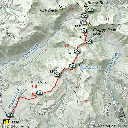
Craggy Peak, Shark Rock, Kirk Rock, Blue Lake, Boundary Trail
|
Length: 12 Miles round trip
Elevation Change: 1600' Elevation gain
Season: Mid-Summer thru Fall
Difficulty: Challenging
Permit: NW Forest Pass Required
Features:
This hike begins off Forest Road #9327-040 which
is a short drive off FR #93. The trail head is
well marked and parking is adequate. Be aware
that this trail permits the use of motor bikes,
so the trail has that distinctive V shape. This
does make the hiking more difficult.
The trail starts fairly level but increases
continually in steepness for the first 3 miles.
In season this hike is surrounded by a grand
display of wildflowers.
At first you will hike along old logging roads
turned trail, but after about a mile things get
steeper and at 2 miles you come to the junction
of Trail #17.
Much of the trail is in dense timber for the first
3 miles, but as you gain elevation you also gain
greater open areas and vistas. At about 3 miles
you will leave a wooded area and you may glimpse
Blue Lake through the trees about 400' below you.
The trail levels off a bit now and for the next
mile or so you will walk through meadows and
open areas and cross an occasional stream. Again
the wildflowers are abundant in season. Not only
will you be offered great views of Mt Adams along
this stretch of trail, but from time to time you
will have glimpses of Mt Rainier, Shark Rock, Kirk
Rock, Craggy Peak, and Mt St Helens.
At about 4 miles you will come to a pond on the
left. The trail then climbs above and away from
the pond offering views of Mt St Helens over the
top of the pond.
At about 5.5 miles you will come to the junction
with Boundary Trail #1. For this narrative I
took the trail to the left and passed Craggy Peak
along the west side. In about 3/4 mile you will
come to the saddle between Craggy Peak and Shark
Rock. It is just a bit further to the base of
Shark Rock where you get excellent views of
Mt Adams and Mt Rainier.
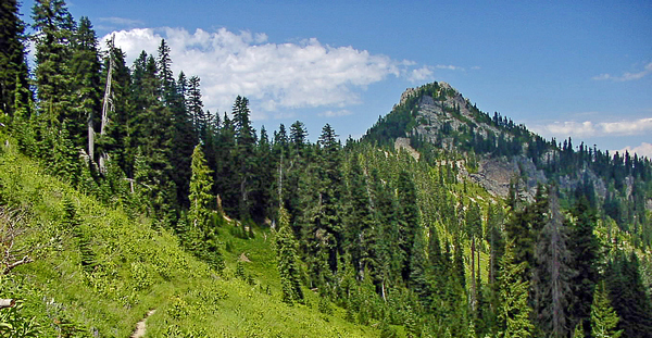
Craggy Peak in the Dark Divide
|
How to get there:
NEW!
Click for PDF Directions Map of this Hike
From Woodland, WA
From Woodland follow SR 503 and the Lewis River
Road for about 48 miles to the community of Cougar, WA. From Cougar, continue
east on the Lewis River Road which will turn into Forest Road 90 after you enter
the Gifford Pinchot National Forest. In about 18.5 miles you will come to the
junction of Forest Road 25. Continue straight ahead on FR25.
From the junction of Forest Road 90 and Forest Road 25 at the far eastern
end of the Swift Creek Reservoir, head north on FR25 for about 5.5 miles to
the junction of Forest Road 93. Bear right and follow FR93 another 13 miles
until you come to Forest Road 9327. Bear left onto FR9327 and follow it
north about a half mile to the trailhead for this hike.
From Carson, WA
If however, you plan to approach this hike from the Columbia River Gorge area, then
begin at Carson, Washington and head northwest on the Wind River Hwy. In 7.5 miles
you will pass through the little community of Stabler, and in another 5.8 miles you
will come to the junction of Forest Road 30. Turn right onto FR30 and follow this
road for 13.2 miles north along the Wind River and then up a steep incline and onto
a plateau where you will come to the junction of the Curly Creek Road. Turn left
onto the Curly Creek Road and follow it downhill past an excellent view area for
about 5.1 miles until you come to Forest Road 90. Turn left onto FR90 and follow
it west for another 4.1 miles until you come to the junction of FR90 and FR25.
Turn right onto FR25.
From the junction of Forest Road 90 and Forest Road 25 at the far eastern
end of the Swift Creek Reservoir, head north on FR25 for about 5.5 miles to
the junction of Forest Road 93. Bear right and follow FR93 another 13 miles
until you come to Forest Road 9327. Bear left onto FR9327 and follow it
north about a half mile to the trailhead for this hike.
|
|
|
A Virtual Hike in the Gifford Pinchot National Forest


|
|


