Length: 16 Miles round trip
Elevation Change: 2200' Elevation gain / 500' loss
Season: Mid-Summer thru Fall
Difficulty: Difficult
Permit: NW Forest Pass Required
Features:
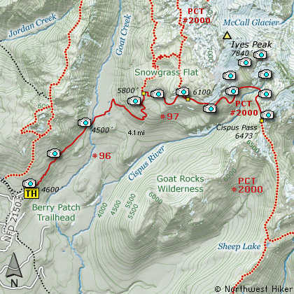
This hike begins on Forest Road #2150.040 near what is
commonly referred to as the Snowgrass Flats TH. The trail
climbs gently for the first half mile then begins a
slow descent to Goat Creek. Most of this part of the
hike is in dense forest with very few view opportunities.
After crossing the creek the trail begins to climb
steeply through a number of switchbacks and talus
slopes toward Snowgrass Flats. At about 4 miles,
just before entering Snowgrass Flats, bypass Trail
#97 heads east and this is the trail you will want
to take to Cispus Basin.
As you follow the bypass trail, you will encounter some of
the most amazing floral displays anywhere in the
Goat Rocks Wilderness, if you get there in mid-July.
This bypass trail is a mile long and crosses a small
stream on its way to the Pacific Crest Trail #2000.
When you reach the PCT, bear right and follow it
another 3 miles to Cispus Pass.
Just before reaching the pass you will walk through
Cispus Basin. In season this valley is dripping in
wildflowers, not to mention a few mountain goats. I
have never walked this part of the PCT and not seen
goats. (But there is always a first time.)
Be very careful about leaving the designated trails.
To return to the trailhead, just follow the PCT back
to Trail #97. Then follow Trail #97 back down to
the junction with Trail #96 and bear left following
this trail back to the trailhead where you began
this most excellent adventure.
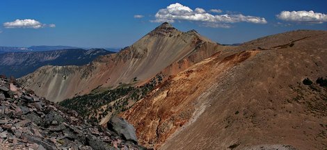
Looking east from a ridge near Cispus Basin
|
How to get there:
NEW!
Click for PDF Directions Map of this Hike
From I-5 junction with US Hwy 12
Travel east on US Hwy 12 for about 48 miles to Randle.
From Randle travel east on US Hwy 12 for about 13.3 miles to the junction with
Forest Road 21. Turn right (south) onto FR21 and follow it uphill for about 5 miles.
At this point you will see Forest Road 2110 on your left, which is the road to the
Glacier Lake trailhead, but you continue straight ahead on FR21. In another 8.1 miles
you will come to the junction of Forest Road 2150. Bear left onto FR2150 and follow it
about 3 miles and you will pass the junction on your left which leads to the
Chamber Lake campground. Continue ahead just a short distance, and you will come to
a spur road on your right. This is the entrance to what is referred to as the
Snowgrass Flats trailhead. This hike and many more begin here.
|